
“Este es nuestro momento (This is our moment),” is the message I share with neighbors of Playa de Ponce as an embedded community participatory action researcher.
The Bipartisan Infrastructure Deal (The Infrastructure and Jobs Act of November 15, 2021) provides unprecedented opportunities to take action on climate resilience. In particular, it makes possible community-led infrastructure investment in historically disadvantaged communities, including those in Puerto Rico. Data on underinvested, polluted communities justifies channeling investment into neglected places, among them coastal settlements that find themselves on the front line of climate change. Barrio Playa de Ponce, included.
Playa de Ponce, Puerto Rico, is an unusual case in the universe of distressed communities. In the past, coastal Playa de Ponce served as a drainage basin for the Matilde, Portugues, and Bucaná Rivers. Mangrove swamps, as well as coral reefs fringing sandy shores provided habitat for wildlife, including abundant fisheries amid once vibrant coral reefs.
Today, much of this habitat has been decimated. Cement and asphalt cover much of the coastal barrio, where water once percolated into soil. Four centuries of economic extraction from colonial interests and local elites produced intensified land-uses and juxtaposed, yet spatially distinct urban processes.
Exploitation under two different nations contributed to these transformations.
A Spanish military report penned in 1873 (Cuerpo de E.M. del Ejército, 1884) notes the defensive and commercial potential of Playa de Ponce’s harbor due to its proximity to rich resources — fertile soils ideal for sugar cane plantations, the raw material of Ponce’s former primary agricultural export.
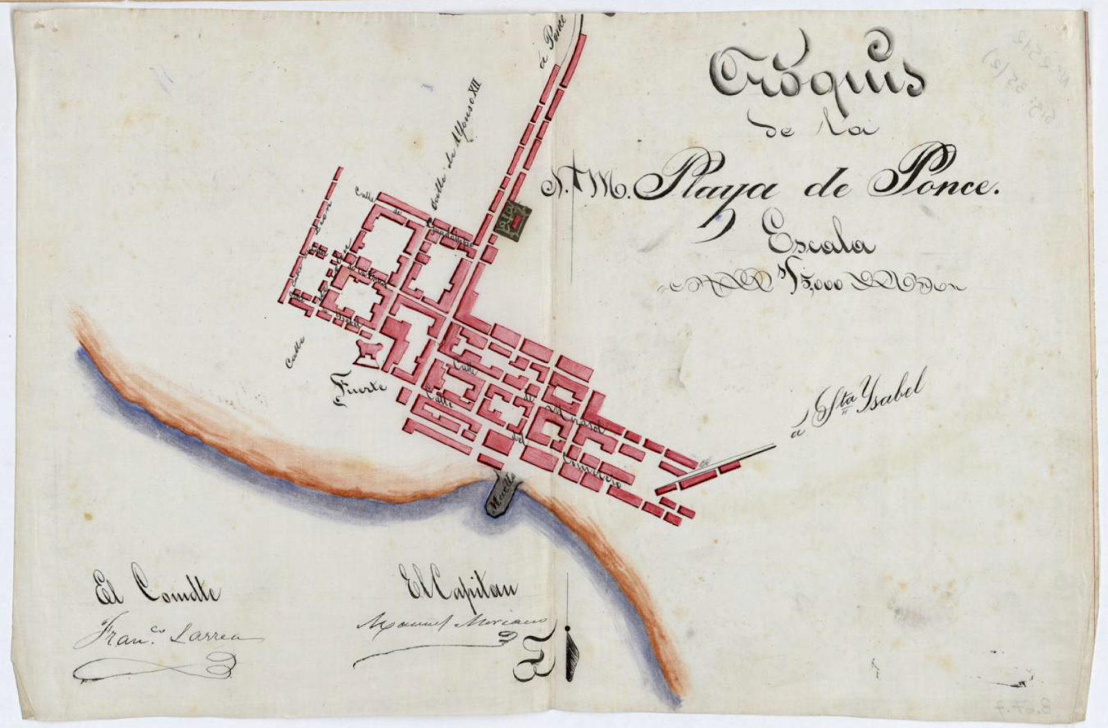
Caption: 1873 drawing of Playa de Ponce’s historic port settlement. The word Fuerte marks the Fuerte de San José, also known as Fuerte de la Playa de Ponce, designed to defend the 18th and 19th century port village from attacks and pillaging.
At the end of the 19th century, seagoing vessels anchored in Ponce Harbor’s deep waters transferred freight by lighters to shuttle freight to and from Playa’s once marshy banks.
“[The] small lighters [were] propelled by long poles in the hands of the [who] plant[ed] their poles securely in the sand or mud and often with great difficulty [to] push the heavy boats through a rough sea” (Pritchett, 1899, p. 3).
On land, newly freed Afro-Caribbeans and immigrants waded into the shallow water, loaded the freight onto their backs and then brought it to shore in Playa’s historic center, a place once bustling with commerce.
Port activity accelerated under the United States’ occupation of the archipelago in 1898, as did US corporate agricultural land acquisitions and consolidations for large sugar plantations. The ensuing land grab displaced thousands of subsistence farm workers, whose small plots of land once sustained them with both food and meager incomes (Ayala & Bernabe, 2009).
Playa’s internal demands for workforce housing due to increasing commercial exploitation, coupled with displaced farmers, put in motion autonomous, as well as urbanization processes.
Seeking opportunity in commerce intensive towns and cities, but without the economic power to purchase land, the former farmers migrated to urban areas and built their homes, forming slum communities on the hazard-prone no-man’s lands of Playa de Ponce’s muddy riverbanks and harbor. The US War Department transported other displaced farm workers to the mainland, fulfilling a need for World War II construction laborers at defense plants and military bases (historymatters.gmu.edu, N.D.).
With heavy influence from local economic elites, the Municipality of Ponce built a “modern terminal with road and railroad connections” (The Secretary of War, 1923, p.2), cementing future economic development in Playa around port infrastructure. By the early 20th century, the Port of Ponce accounted for 25% of Puerto Rico’s import-export business (The Secretary of War, (1923, p.2).
Today’s deep water megaport, Rafael Cordero Santiago Port of the Americas, was a century in the making. In the process, the US Corp of Army Engineers’ works project displaced thousands of informal communities in Playa, bulldozing places with names such as Villa Lucy, Santo Domingo, and Boca. Residents faced expropriation. In some cases, they were housed in new developments funded through HUD’s blight elimination program. HUD funding built these homes in Playa’s floodplain.
Despite the historic challenges, Playa’s residents persist, creating a Caribbean community rich in cultural, artistic, and sports traditions, many of which is still very much alive today. Yet, changes to the climate coupled with disinvestment in infrastructure maintenance, have left neighbors exposed to riverine flooding and storm surges, inundating homes and businesses with hazardous sewage water.
These circumstances prompted Paster Roberto Ortiz to call me one fall day in 2015. “We have a problem. Can you help?”
Frankly, I had no idea what or how to help, but the circumstances occurring in my own barrio were untenable to me as a neighbor. Within a week, opportunity knocked in the form of an email about EPA’s Equipment Loan Program for environmental water quality testing.
I called Roberto immediately and suggested that if the community could work together to gather samples, the EPA-loaned equipment could help us to provide empirical evidence of the problem, elevating the infrastructure issue to one of public health.
“Eso es nuestro momento (This is our moment),” I told him. And so it was.
