In our previous article describing speculation on vacant urban land, we pointed out that the attention paid to vacant housing often overlooks another type of pernicious vacancy: housing units that aren’t even built in the first place. Sometimes this looks like plots of land lying vacant for decades, even in the face of exorbitant rents, earning juicy speculative profits for the owner as their land rises in value. But speculative profiteering doesn’t only occur on wholly vacant land. It also occurs on underutilized land. In this article, we examine the social harms that arise from underutilized land, consider ways of measuring it, and propose policies to discourage it.
Picture a valuable piece of land in a thriving city, surrounded by tall buildings and could profitably be redeveloped into apartments, but which instead stubbornly remains as a single family home for decades. As the city develops, the land under this house will continually rise in value as demand for housing grows more and more intense, returning capital gains for the homeowner even while the housing market is starved of supply. All of the households who could have lived in the unbuilt apartments must instead look for housing in alternative locations. This type of underutilization therefore holds back the supply of floorspace for homes and businesses in our most productive places, acts as a barrier for households looking to relocate to locations with better opportunity, exacerbates urban sprawl, and increases the combined cost of housing and commuting.
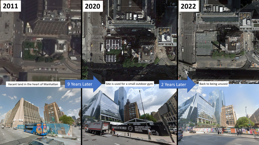
For example, the 0.6 acre plot of land located at 358 10th Ave in Manhattan is located merely two blocks from Penn Station and five from the Empire State Building, but has barely been used as more than a parking space even while the glistening skyscrapers of Hudson Yards have sprung up around it. While the land was finally put to use for the 15,000 square foot Equinox outdoor gym during 2020, this was far below the 250,000 square feet of retail or commercial floorspace that could legally and profitably be built on the site. Thus, while this site would be missed by most analyses which focus on wholly vacant land, it is clearly underutilized relative to what could profitably be built on the site, providing plenty of additional commercial and residential floorspace in one of the most hotly demanded and highly-priced locations in the world.
For a more formal definition, urban policymakers typically consider land to be underutilized if it is currently being used well below its “highest and best use” (HABU) based on what market signals indicate is being demanded at that particular location. Investors consider HABU when deciding how much they are willing to pay for a given property, because they are concerned with the profits that can be earned by putting the property to the maximum of its “legal permissibility, physical possibility, financial feasibility, and maximum productivity”. Because the maximum that they will be willing to pay for the property depends on what can be legally and profitably be developed, the market price will naturally incorporate information about the site’s HABU.
Crucially, HABU does not assume that a Burj Khalifa should be built on every piece of land in the country. Rather, it is sensitive to both the demand for various land uses at a given location, as well as the construction costs associated with meeting that demand, and legal constraints which limit the range of permissible uses. This explains why properties which are “upzoned” to allow for more intensive development often enjoy a windfall jump in value, to reflect their newly-legal HABU. Similarly, because assessors are charged with determining the fair market value of each property within their jurisdiction, HABU is also factored into the valuations conducted by municipalities for property tax purposes.
This gives us an idea about how we might usefully measure the presence of underutilization in our cities. If we had clear information about the HABU of each property, those which are being used well below the HABU could be labeled as underutilized. Recall the example above of a single family home sitting in a location that could easily support medium-density housing. However, as the precise HABU for each property is unknown, it can be quite difficult to create a holistic measure of underutilization that can be deployed at scale.

Studies in the academic literature have so far failed to unify around a consistent method for identifying underutilized urban land. Li et al. (2019) studied land use in the rapidly urbanizing Chinese city of Changchun and used visual inspection of satellite images and ground-truthing to measure four types of underutilization: wholly vacant lots; urban land still being farmed; abandoned industrial land; and land with the appearance of rural settlements even while surrounded by taller buildings. However, these classifications are unlikely to be appropriate for American cities.
In their 2000 study of 99 American cities, Ann Bowman & Michael Pagano found that there was not even a standardized measure of vacant land across cities, with measures of underutilization being even more opaque. While clearly identifying what constitutes vacant land, the American Planning Association does not offer a definition of underutilized land. Some cities, such as Philadelphia, do include a measure of abandoned buildings in their record-keeping, however these typically only count properties that have gone beyond underutilization and into full abandonment. Without consistent statistical methods for identifying underutilized land, researchers and policymakers will fail to understand the true extent to which desirable land within our most productive cities is being wasted by being held below its most productive use, all-the-while increasing in value for the passive landowner. Failing to measure this problem can therefore make us blind to one of the most pernicious forms of rent-seeking, one which drains productivity and leaves all of us worse off at the end of the day.
Here at CPTR, we have long been fascinated by both vacant and underutilized urban land, and have conducted detailed investigations into their presence in New York City. Indeed, our map of vacant land in NYC enables users to zoom in and identify specific properties that are either vacant or underutilized. In this map, we define properties as underutilized if the value of the buildings on top of the land are worth less than 15% of the property as a whole. For example, if a piece of land is worth $900,000 but has a building worth only $100,000 on top of it, we consider it highly likely that such a property could profitably be redeveloped into a more intensive use, and therefore code it as underutilized. Using this narrow measure, we identify 8,200 underutilized parcels across NYC, occupying more than $1bn worth of land.
One prior study of underutilization in NYC relied upon a more generous threshold, classifying parcels as underutilized if the site had built floorspace equal to less than half of the maximum that is legally allowed under current zoning. Using this measure, Vicki Been and her coauthors from NYU’s Furman Center found that one quarter of residentially-zoned parcels in NYC were underutilized in 2009. We apply their definition to the latest set of MapPLUTO data and continue to find that 25% of all residential and commercial lots continue to be classified as underutilized.
We compare these two alternative definitions of underutilized land within NYC in the two maps below:
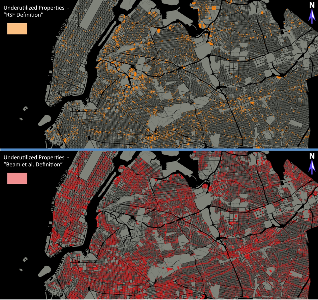
While some consistent patterns emerge, such as the clusters of underutilized land along arterial transportation routes, the number of parcels that can be considered underutilized can differ wildly based on the definition being used. It is therefore imperative that researchers continue to develop measures of underutilization and compare them across different cities, ultimately working towards consensus around one consistent and defensible measure that can be used for studying the phenomenon of underutilization over space and time. For example, one approach could algorithmically test each parcel of land in the city to determine whether it could profitably be bulldozed, redeveloped into the largest amount of floorspace that is permitted by current zoning, and then sold at current market prices. Parcels where such a redevelopment could easily be done while providing a healthy return for the landowner could therefore be classified as currently underutilized. Here at CPTR, we would like to further research on this topic and welcome contact from interested parties.
In a soon-to-be-released report, we have analyzed the socioeconomic and geographic predictors of underutilization across different parts of NYC, using the more generous definition depicted in the map on the right above. We find that underutilization is more common on lots which are more difficult to develop, namely those which are irregularly shaped, lie in a floodplain, have no street frontage, or are in a struggling neighborhood. However, we also observe that underutilization is more common in locations prime for speculation, such as those closer to the Empire State Building, near to subway stations, and on parcels that have recently been rezoned. These findings are consistent with the patterns of speculation on NYC’s vacant land that we identified in a previous blog.
But regardless of the precise definition of the term, why does underutilization happen in the first place? Economic studies demonstrate that profit-seeking landowners will not redevelop their property until the moment that they can maximize the expected return from the newly-developed use, after accounting for redevelopment costs and the lost revenues from the pre-existing use. Whereas capital gains from rising land values can be enjoyed with little effort by the landowner, redevelopment is costly and fraught with uncertainty, and many landowners will prefer to delay redevelopment, ultimately leading to the stubborn presence of underutilized parcels even throughout thriving cities like NYC.
Policymakers and activists trying to reduce the amount of vacant land in their cities often advocate for taxes on vacant land, arguing that such a tax will penalize landowners who leave their property vacant and bring the land into use. While this is reasonable, and CPTR has previously supported taxes on vacant land, one weakness of this approach is that it will not meaningfully address the problem of underutilized land. Indeed, it may instead result in landowners merely trying to avoid the vacancy tax by engaging in some token use of the land, such as for surface car parking.
A far more preferable approach is to raise tax rates on all land, with a land value tax (LVT). This tax is applied to the market value of each parcel of land. As discussed above, market values incorporate information about the HABU of each piece of land, meaning that the LVT charged to each landowner will be directly proportional to the HABU of their land. Similar to vacancy taxes, this will place a greater financial penalty on those landowners who are underutilizing their land, encouraging them to redevelop to HABU as soon as possible. Indeed, studies have repeatedly shown that LVT lowers vacancy rates and encourages greater levels of infill development. Advocates for vacancy taxes should therefore take note: land value tax is the best type of vacancy tax.
